
Pure Michigan: Spots That Deserve The Love
The places the brochure doesn't mention. The ones worth finding.
Every Michigander has a list.
Not the official list. Not the Pure Michigan commercial list with Sleeping Bear and Mackinac and the Pictured Rocks kayak tour that books up in February. That list is fine. Those places are beautiful and they earned their reputation and you should go to all of them.
But the other list. The one you share carefully, with people you trust, with the mild internal conflict of wanting them to experience something wonderful and also not wanting the parking lot to get any fuller than it already is. The waterfall that doesn't have a sign. The campground that never seems to show up in searches. The lake that looks like nothing from the road and opens up into something you weren't prepared for.
Michigan is enormous and complicated and full of places that haven't been photographed into clichés yet. The Lower Peninsula alone has 11,000 inland lakes. The Upper Peninsula has waterfalls that don't have names on most maps. The Thumb has a whole coastline that people drive past on their way somewhere else without ever stopping.
Here are the ones worth stopping for.
The Lower Peninsula
Negwegon State Park — Alpena County
The park that doesn't want to be found

Negwegon is technically on Lake Huron. It has miles of shoreline, old growth forest, and hiking trails through landscapes that look like the UP transplanted to the northern Lower. It is one of the most beautiful state parks in Michigan.
It also has a two-mile dirt access road that discourages casual visitors, no modern campground facilities, and almost no signage that announces its existence to passing traffic.
This is a feature, not a bug.
The primitive campsites at Negwegon require a reservation and a willingness to carry everything in on foot. What you get in return is a stretch of Lake Huron shoreline that on a summer weekday will have you questioning whether you've somehow ended up in a national park that nobody told you about. Clear water, limestone shelves, forest right to the water's edge.
If you want the Lake Huron experience without the Tawas or Rogers City crowd — Negwegon is your answer. Just bring everything you need because there is nothing else out there.
Getting there: South of Alpena off US-23. The turnoff is easy to miss. That's intentional.
Best for: Primitive campers, hikers, people who want Lake Huron to themselves.
Don't miss: The shoreline trail in the morning when the light comes through the forest onto the water.
Ocqueoc Falls — Presque Isle County
Michigan's largest waterfall that nobody talks about

Here is a fact that surprises most people: Michigan's largest waterfall in the Lower Peninsula is not on any major tourist route, doesn't appear in most Michigan travel guides, and has a parking lot that fits maybe thirty cars.
Ocqueoc Falls on the Ocqueoc River is a series of wide, low cascades over limestone shelves — not dramatic vertical drops but broad, accessible, genuinely beautiful moving water that you can wade in, picnic next to, and have largely to yourself on most summer days.
The falls are free. The campground nearby is a Presque Isle County park that costs almost nothing and books up less than half the state parks in the area. The Ocqueoc Pathway, a hiking trail that loops through the surrounding forest, is one of the better easy hikes in the northern Lower that most people have never heard of.
Getting there: Off Ocqueoc Road west of Rogers City. Follow the small brown signs. They exist.
Best for: Families, casual hikers, anyone who wants a waterfall experience without the Tahquamenon crowds.
Don't miss: Wading in the falls on a hot day. The limestone shelf creates natural wading pools that are perfect for kids.
The Tip of the Thumb — Port Austin area
Michigan's forgotten coastline

People drive to the Thumb to get through it. They're on their way to somewhere else and the Thumb is the geography between Warren and that somewhere else and they don't stop because there isn't anything there.
There is something there.
Port Austin sits at the absolute tip of the Thumb on Lake Huron and it is, genuinely, one of the most underrated small towns in Michigan. Turnip Rock — a mushroom-shaped rock formation in the water offshore — is accessible only by kayak or paddleboard, which means the people who see it in person earned it, and the people who see it in photos want to earn it too. Port Crescent State Park just west of town has some of the best hiking trails on the Thumb, a sandy beach on Saginaw Bay, and campgrounds that book up much slower than the popular west coast parks.
The Thumb in late summer — August into September — is golden hour all day. The light on Lake Huron from the Thumb coast in the evening is the kind of thing that makes people pull over and just stand there.
Getting there: M-25 loops the entire Thumb coastline from Port Huron to Bay City. The whole drive is worth doing once.
Best for: Kayakers for Turnip Rock, campers for Port Crescent, anyone who wants Lake Huron without the Lake Michigan crowd.
Don't miss: Kayaking to Turnip Rock — rent from one of the Port Austin outfitters if you don't have your own. The paddle is about three miles round trip and worth every minute.
Rifle River Recreation Area — Ogemaw County
The river camping that the RV crowd doesn't know about

The Rifle River Recreation Area is 4,449 acres of lakes, rivers, forest, and camping in the middle of the Lower Peninsula that occupies a strange sweet spot — too far north for the casual day tripper, too far south and too little known for the UP crowd, just right for the person who wants a genuine wilderness camping experience without driving six hours.
The Rifle River runs through the property and it is one of the best canoe rivers in the Lower Peninsula — clear, moving, surrounded by forest, with a current that makes the paddling effortless and the scenery continuous. The campgrounds are dispersed enough that you don't feel like you're in a parking lot with fire rings.
Flooding and clear sandy streams, lakes for fishing, trails for hiking, rivers for paddling. The Recreation Area does everything well and does it without a crowd because it's not on anyone's shortlist of famous Michigan places.
Getting there: Off M-33 south of Rose City.
Best for: Canoe campers, anglers, families who want water access without the popular destination pressure.
Don't miss: The canoe trip down the Rifle River. Rent locally or bring your own — the full run through the property takes most of a day and it's one of the better river days you can have in Michigan.
Pigeon River Country State Forest — Otsego and Cheboygan Counties
The elk are real and they are enormous

Michigan has a wild elk herd. Not a small one — somewhere around 1,000 animals in the wild, living in the Pigeon River Country State Forest in the northern Lower, and largely unknown to people who didn't grow up hearing about them.
The elk are most visible at dawn and dusk, in the meadows and forest edges of the state forest, between August and October when the bulls are in rut and you can hear them bugling across the hills. There is a specific DNR elk viewing area off Sturgeon Valley Road where sightings are consistent enough that it feels almost guaranteed — but even a drive through the forest roads at first light in September has a good chance of producing an encounter.
Elk are very large. Larger than you expect. Standing in a field at dawn watching a bull elk cross thirty feet away is a wildlife experience that most people associate with Yellowstone and is quietly available in northern Michigan.
The camping in Pigeon River Country is dispersed and primitive and excellent. The trout streams — the Pigeon River, the Black River — are among the best in the state.
Getting there: South of Vanderbilt off Sturgeon Valley Road.
Best for: Wildlife watchers, fly fishers, anyone who wants to tell people they saw wild elk in Michigan and watch their faces.
Don't miss: The dawn elk viewing in September. Set the alarm. Go.
The Upper Peninsula
Tahquamenon Area — But the Parts Nobody Goes To
Beyond the falls

Everyone goes to Tahquamenon Falls. The upper falls, the lower falls, the rowboat rental between them — it's a classic Michigan experience and deservedly so. But the Tahquamenon area has significantly more to offer than the falls themselves, and almost all of it sees a fraction of the visitor traffic.
The North Country Trail runs through the area for miles in both directions — east toward Paradise and the Lake Superior shoreline, west into forest that goes largely undisturbed for long stretches. The Tahquamenon River downstream from the falls opens into the wide, tea-colored water that moves toward Whitefish Bay and Lake Superior, and canoeing that stretch of river is a different experience entirely from the waterfall tourist area.
The Rivermouth Unit of the Tahquamenon Falls State Park — where the river meets Whitefish Bay — has a campground that is genuinely one of the best-positioned in the UP. You're camping at the mouth of a wild river where it enters Lake Superior. Moose sightings are not unusual. Loons are constant.
Getting there: Paradise, Michigan is the hub. Rivermouth Unit is north of town on M-123.
Best for: Canoe campers, North Country Trail hikers, people who want the UP experience without the falls parking lot.
Don't miss: Canoeing the lower river at dawn. The mist on that tea-colored water in the morning is something.
Drummond Island — Lake Huron
The island the tourists forgot

Drummond Island is accessible by ferry from Detour Village at the eastern tip of the UP — a twenty-minute crossing that most people have never taken because most people don't know Drummond Island exists.
It is the largest freshwater island in the United States. It has 150 miles of shoreline, inland lakes, extensive ORV trail systems, world-class fishing in the surrounding Les Cheneaux water, and a year-round community of people who chose to live there specifically because it takes some effort to get to.
The effort is the point. The ferry crossing creates a psychological break from the mainland that changes how the trip feels from the moment you board. You're on island time now. The roads are slower. The fishing is better. The skies at night — away from any meaningful light pollution — are the kind of dark that reminds you what stars actually look like.
Getting there: Drive to Detour Village at the far eastern tip of the UP. Take the ferry. Let the island figure out the rest.
Best for: ORV riders, anglers, kayakers in the Les Cheneaux channels, anyone who wants genuine island remoteness without going to an ocean.
Don't miss: A night sky from anywhere on the island. Bring a blanket. Look up for a long time.
Black River Scenic Byway — Gogebic County
Five waterfalls and nobody knows about four of them
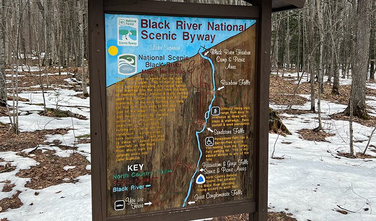
The Black River in the western UP runs through a gorge on its way to Lake Superior, dropping over five separate waterfalls in less than ten miles — Gorge Falls, Potawatomi Falls, Sandstone Falls, Rainbow Falls, and Great Conglomerate Falls. There's a trail that connects all five, running through old growth hemlocks and pines along the river, and it is one of the best hikes in Michigan that almost nobody outside of the western UP talks about.
The Black River Harbor at the end of the road is a Lake Superior harbor with a campground, a covered bridge, and a beach on the big lake that will be cold and dramatic and worth sitting at for as long as you can stand the wind.
The western UP — the Gogebic Range, the Porcupine Mountains, the Black River area — is the part of Michigan that feels most like somewhere else entirely. It feels like the Pacific Northwest. It feels wild in a way that takes a minute to adjust to if you came from the suburbs.
Getting there: North on Black River Road from Bessemer — County Road 513.
Best for: Waterfall hikers, anyone exploring the Porcupine Mountains area, people who want Lake Superior without the Pictured Rocks crowd.
Don't miss:All five waterfalls in one hike. The trail is not difficult. The payoff is enormous.
Presque Isle Park — Marquette
The locals' park in Michigan's best city

Marquette is not a hidden gem — it's the largest city in the UP and it has a reputation. But Presque Isle Park, the city park that juts into Lake Superior on a wooded peninsula at the north end of town, is the part of Marquette that visitors miss because it's not in the highlights and locals tend to keep it quietly to themselves.
The park road loops the peninsula with Lake Superior on both sides — the water changes color depending on the light and the depth, going from pale green in the shallows to a deep cold blue offshore that looks nothing like any other water in the Midwest. There's a swimming hole cut into the rocks on the south side that Marquette residents have been jumping into for generations. There's a small beach. There are trails through the forest on the interior of the peninsula.
And there's the view from the north point at sunset — Lake Superior in every direction, the Huron Mountains in the distance, the kind of view that makes you understand immediately why people move to Marquette and then never leave.
Getting there: Follow Lakeshore Boulevard north from downtown Marquette.
Best for: Anyone visiting Marquette, sunset chasers, swimmers who don't mind cold water which in Lake Superior is a firm requirement.
Don't miss: The rock swimming hole. Jump in. The cold is the point.
The One Thing These Places Have in Common
None of them are hard to get to. None of them require special equipment or unusual planning or anything beyond deciding to go somewhere that isn't on the default list.
They just require knowing they exist.
Michigan rewards the curious traveler in a way that almost no other state does — because it's large enough that there are genuinely unknown places, and small enough that those places are never more than a day's drive from Warren. The 11,000 inland lakes. The two peninsulas. The four Great Lakes. The rivers and forests and dunes and waterfalls that don't have Instagram accounts yet.
All of it sitting there, waiting for the people who went looking.
Your rig is stored. The map is open. The only question is which one you're hitting first.
Have a hidden Michigan spot that deserves more love? Drop it in the comments — this list should be a living document and you know something we don't. Share it.


Comments